- About Us
- Committees
- SUT Houston Branch Executive Committee
- Offshore Site Investigation and Geotechnics (OSIG)
- Subsea Engineering and Operations - Atlantic (SEO-Atlantic)
- Group on Environmental Forces (GEF)
- Robotics & Automation (R&A)
- Marine Renewable Energy Committee (MREC)
- Education Committee
- SUT Young Professionals
- Advisory Committee
- School Touring Committee
- Women in Industry
- Become a Member
- Student Chapters
- Mentoring Program
- Learning Programs
- Events
- News
- 2023
- 2022
- 2021
- 2020
- SUT-US Champagne & Conversation Series Edition 5
- SUT-US Makes Its 15th Appearance at Subsea Tieback Forum & Exhibition
- SUT-US Brings Its School Touring Program to the Largest School District in Houston
- SUT-US Brings Its School Touring Program to the Largest School District in Houston
- SUT-US Champagne & Conversation Series Edition 6
- Making History - SUT-US Elects its First Woman Chair and President
- Scholarship Awards Ceremony 2020
- 2019
- 2018
- 2017
- Dr. Medina-Cetina Presents at European Geosciences Union (EGU) GIFT Workshop
- 'Geology Rocks' 500 at Thornton Middle School
- SUT-SEO Presents Subsea Awareness Course
- Society for Underwater Technology Awards Six at Scholarship Reception
- School Touring Reaches Opal Hamilton Students
- Passion Runs Deep in the Subsea Engineering Society
- Galveston Student Chapter Presents First Short Course
- Promoting A Welcoming Environment, SUT Actively Combats Discrimination and Sexual Harassment
- Subsea Awareness Course Offer its Expertise to Mexico's Industry Professionals
- SUT-US Gifts this Academic Year's Annual Sponsorship Checks to its Student Chapters
- SUT-USA Launched the New Committee: Group on Environmental Forces
- SUT-US Launches a New Student Chapter at Rice University
- 2017-2018 Scholarship Awards Ceremony
- 2016
- Press Releases
- Subscribe
Accelerated Layout and Design Decisions for Offshore Windfarms through Integrated Geo-Data Management
Starts: Thu, May 19, 2022 9:00 AM CSTEnds: Thu, May 19, 2022 10:00 AM CST
Become a Member Now
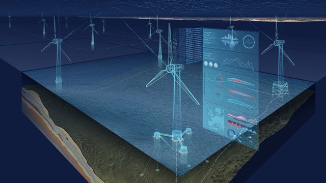
To help facilitate the energy transition, geo-data specialists are now delivering integrated environmental, geophysical, geotechnical, and geoconsulting data and services to offshore renewables clients. A key component of this integration is the development of the ground model. The geo-data needed to develop a robust ground model in support of the life-of-field for an asset could span several years of acquisition and analysis potentially amounting to terabytes of raw and processed geophysical data; thousands of onshore and offshore lab tests and core descriptions; hundreds of hours of benthic video; and daily wind, wave, and current measurements from metocean sensors. Initially, these siloed geo-data streams lack the “connectivity” needed to support efficient, informed decision-making for the development of offshore renewables.
To address the challenge of integrating these large disparate data volumes and building the ground model, web-based geo-data engagement platforms are being developed. These web-based platforms help project stakeholders increase collaboration, streamline decision-making, and shorten project siting and development schedules. This ‘digital twin’ of the project development bridges the gap between the immense volumes and variety of data collected and the extraction of meaningful insights.
Making informed decisions at an early stage and throughout the development of the ground model is integral to project success, allowing stakeholders to reduce site characterization uncertainty faster, and thus plan a more efficient, reliable, and sustainable development.
Reference: A Data-Driven Revolution (pages 52-57 from Energy Global - Autumn 2021)
About the presenter:
 Kathryn Rovang Senior Geoscientist GIS Analyst
 Mrs. Rovang joined Fugro in Nov 2017. Her current role includes implementation and administration of the Enterprise GIS environment including product engineering and development for client delivery solutions, ensuring production database integrity, and internal workflow optimization. In addition to her Enterprise GIS experience, Ms. Rovang is involved with offshore site characterization projects that include the integration of various geo-data to evaluate engineering constraints and geohazards. Prior to her role at Fugro, she worked in the utilities industry which initially sparked her interest in Enterprise database design and the concept of a ‘global GIS’, that collaborates real-world representation with IT design thinking. She has BSc’s from the University of Houston in Geology, Geophysics, and Archaeology and a GIS Analyst II certification.
Donate to SUT
 Add this Event to your
Outlook Calendar
Tickets
Webinar
Available Online Only
$30.00 Members Webinar
$35.00 Non-Members Webinar
FREE Student Members Webinar
$10.00 Student Non-Members Webinar
Add this Event to yourOutlook Calendar
May 2022


